Visualize hierarchical atlases with this tool
TNTatlas is a handy, easy-to-use application specially designed to help you view hierarchical atlases by analyzing them.
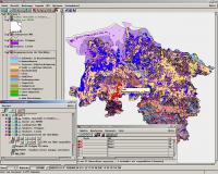
TNTatlas uses HyperIndex stacks: spatially related layers of information from different sources and data types linked geographically or spatially. You author a HyperIndex stack of spatial information by using TNTmips. The stack you build will use objects from one or more TNT Project Files: collections of raster, vector, shapes, CAD, TIN, database, and text objects.
TNTmips has a variety of tools to create and edit objects, and you may import digital materials from a wide variety of formats such as TIFF, TARGA, GIF, DXF, DBF, and other commercial image processing, mapping, CAD, and database formats.
Your HyperIndex stack can also include database information attached to graphical elements or image cells on the display, so the user can select any line element or cell and immediately view the attached database record.
The TNTatlas user could select a segment of a red highway and view database information that includes surface material, wear condition, traffic statistics, and scheduled repairs.
The objects and views in your electronic atlas can be as complex as you like. Your stack of spatial information can be established to display multiple objects:
· side-by-side (before and after views),
· overlaying objects (vector and CAD lines over raster images),
· graphical symbol overlays (such as icons or pie diagrams), or
· additional reference information (like map grids, text blocks, and legends).
TNTatlas gives you the opportunity to publish spatial information for wide-scale, multi-platform distribution. You can put together complex stacks of relational imagery, maps, drawings, and databases for use everywhere from the kiosks in the front lobby to the president's suite.
Whether you use TNTatlas to support a number of network users with frequently updated project materials, or to publish a single stack that can find its way to computers anywhere in the world, you will be taking advantage of the new ways TNTatlas provides for viewing and managing spatially related materials.
TNTatlas is the electronic publication tool you need for today's geospatial information.
Operating system:Windows XP / Vista / 7 / 8 / 10

Database management software that helps you to organize your school/teacher data.
Price: $75.00, Rating: 5, Downloads: 177
Download

OkMap is a free software for many outdoor activities: Trekking, Off road, Mountain bike, Sailing, Hunting and fishing, Finding mushrooms, Soft air, Geocaching, And many others...
Price: $14.50, Rating: 10, Downloads: 113
Download

The program converts text to speech. All computer voices installed on your system are available to Balabolka. The program allows you to convert text into a WAV, MP3, OGG or WMA audio file so you can listen later.
Price: $0, Rating: 5.5, Downloads: 105
Download

With Photo Lottery Director you can create and manage your own photo lottery. A lottery contains up to 99 scenes with certain sequence, one or more winners can be drawn in each scene.
Price: $49.95, Rating: 5, Downloads: 98
Download

Save money by always having your car costs under control with this program: Fast and simple collection of all expenditure for your car/motorbike. Collect your insurance costs, car tax, repair costs and also your fuel costs. With many tips.
Price: $19.95, Rating: 8, Downloads: 89
Download